
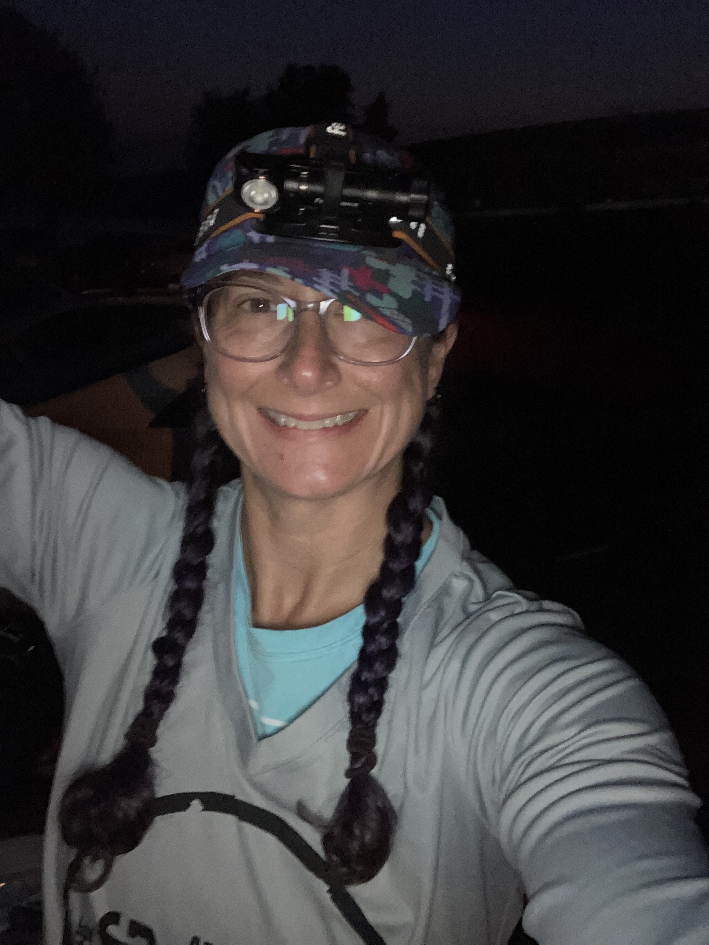
Steve and I originally planned to each do this race solo but after 2 1/2 yrs of winning the Covid game we finally succumbed over Labor Day weekend. The lingering fatigue was bad for both of us but I was about four days ahead of Steve in recovery so I forged ahead on my own! The race location was the beautiful East Fork State Park just southeast of Cincinnati.
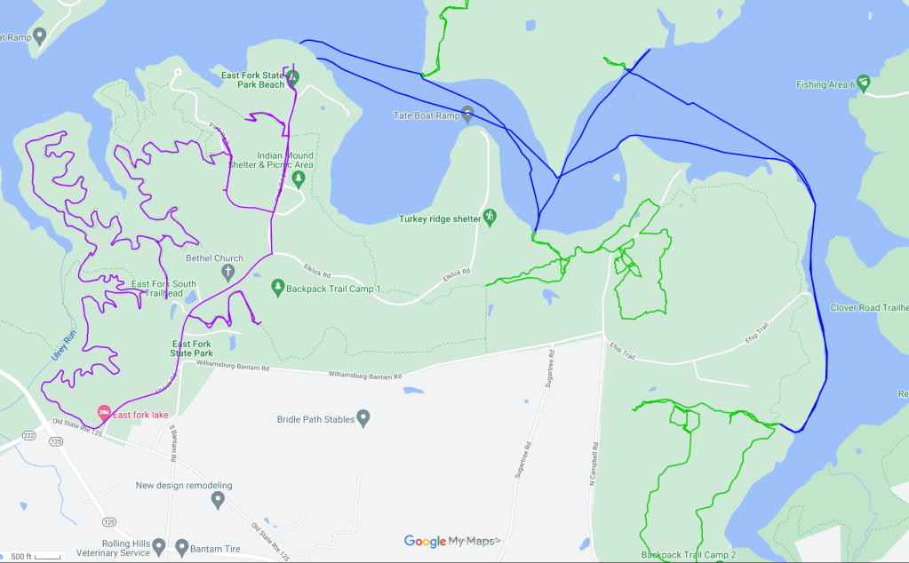
Race day dawned clear and warm. We received our maps at check in and had plenty of time to route plan. The race format was boat to various locations and then collect points via foot. There were 24 CP’s in this section and once we moved on to the biking, we couldn’t go back to this part. The biking section was going to be fast and had 10 CP’s that all were right on the trails. My plan was to give myself 3 hrs to clear the biking. This left me with 9 hrs to get really lost in the woods! Looking at the scope of the lake and knowing I was in a rental kayak that is not known for its speed I narrowed down the regions I wanted to focus on.
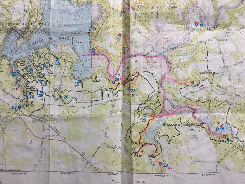
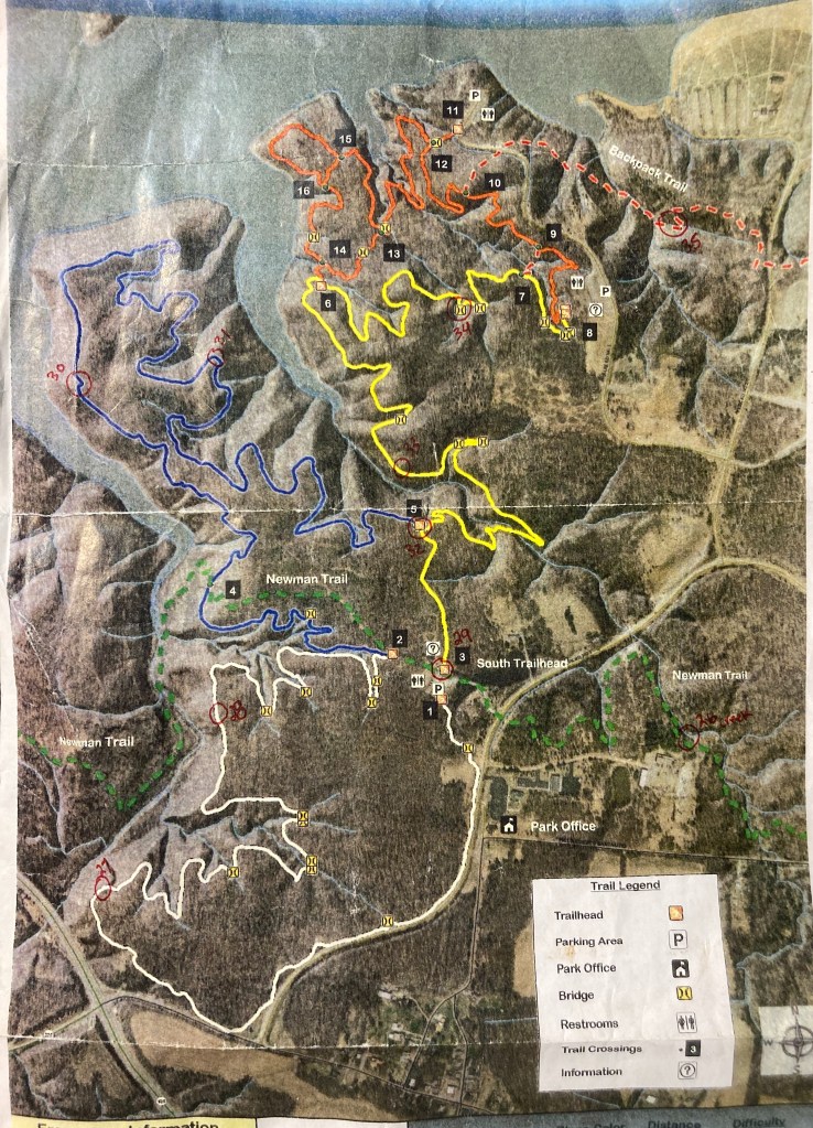
Paddle & Hike Leg 1 – (2 hr 5 mins) – The lake was perfectly smooth and as soon as the RD said “go” a DNR boat went by and made some pretty big waves just as we were getting in our boats. I don’t think anyone actually swamped but there were more wet feet than desired I bet! I paddled over to the first area that had 5 CP’s to collect. I landed at CP 3 and headed up the spur. Pretty quick I saw a CP flag that was looking rather ratty. The team in front of me punched their passport but when I stopped to check, I saw that it wasn’t the CP number we needed. It might have been one from a previous year or just a decoy! Farther up the spur was the correct punch. From CP 3, I circled clockwise, following the trails and the map, trying to focus on the topography more than the trails. The maps weren’t great, it was hard for me to see the details of the terrain. Part of the issue was a color change about half way across the paper where the water went from blue to pink and man, it messed with my brain more than it should! On route to CP 7, I overshot the correct spur and headed down one to the north. Going all the way out to the lake gave me a clearer view and I figured it was one over. As I was making this decision I heard the teams behind me shout that they saw something orange on the next ridge. I crossed over, punched and then headed out to #14. This was in a big reentrant and again the map was super challenging for me to see the details. My backstop was when our trail intersected another trail. I ended up at the point and then should have taken a bearing but the shiggy level was a 10 at that location and I wasn’t feeling it. I backtracked to what I thought was the reentrant and then headed down. The other two teams were likewise searching the area and in the end, I used their beta to find CP 14. One of my main goals for this solo race was to really practice my nav skills so I was hoping to find myself alone in the woods soon. From CP 14 I decided to do a backtrack to where I thought the trail to CP 5 was and then shoot a bearing. This plan worked out pretty well and CP 5 wasn’t an issue. The next part of the plan was originally to continue on foot to CP 4 but I decided to head back to the boat and get 4 from the water on the way out to CP 22. It’s hard to say which would have been faster but the decision was made!

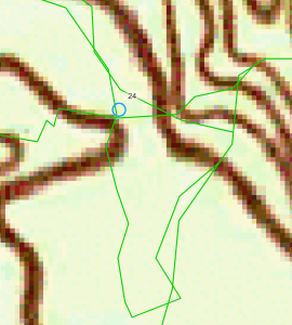
Paddle & Hike Leg 2 – (2 hrs 20 mins) – From CP 3 I headed across the lake to the next foot section to collect 2 points. Dear reader, this is where the first mistakes were made. CP 24 was not an issue, other than the sheer cliff like ridge we had to scramble up to get to it! From there, a nice trail marked both on the map and in the forest lead the way to CP 23. I was smart and marked where I came out of the woods from CP 24 onto the trail so I could go back the same way. Having lost my boat at a race a few years ago in KY, I was not keen to do that again! The trail system cut across an old road that led down the lake and I used this as a known location and cut out a section of trail. From the next road + trail intersection, I thought I was following the topography ok and went off trail towards the reentrant. Looking back at my trace, on my initial approach I was only 500 ft away from the CP when I went rogue and angled too far left. It was simply over the next small ridge! An hour later, after bailing back to the road to escape the spaghetti bowl of wrong turns, I found a decent attack point and took a bearing. Thankfully this got me to the CP! On the way out I passed the same feather I had seen on the ground earlier and yeah, that felt great… Having lost a lot of time on one point I thought I’d be smart and short cut over to my boat earlier on the trail than I had marked. I actually did short cut over the trails and cut out a small section successfully. How I managed to screw up the second short cut to the boat is a mystery! Looking back at my trace, it appears I was easily within feet of CP 24! The shiggy was super thick so I guess I just didn’t see it and my natural inclination appears to be a left handed trajectory when not paying attention! I knew I had a major screw up when I came out on a trail that then intersected with more trails. Rather than risk another miss, I stayed on the trail and used the marks I had so conveniently made earlier to head back to my boat! All told it was about 1.8 miles of wasted travel and I’m guessing an hour easy of time lost!
Paddle & Hike Leg 3 – (37 mins) – Super happy to see my kayak again, I headed across the lake to do a quick grab of CP 4, the one I had dropped in the first loop. It was an easy paddle with a very short hike up a reentrant to the CP, probably the 2nd easiest of the day!

Paddle & Hike Leg 4 – (3 hrs 41 mins) – This would prove to be my last section but I was pretty optimistic going into it. I had set a timeline to leave myself 3 hrs for the biking leg and this paddle section was the furthest I was going to be able to go and still make my cutoff. As I made my way along the lakeshore, I saw several spots where racers had taken their boats out and started the trek. I stuck with my plan which was to paddle to the large reentrant that led to CP 22. Again, the details on the map (or lack thereof) thwarted me and I went right past the checkpoint. I thought it was in the main huge reentrant and didn’t see that it was actually off the big one in a smaller one! So I went up the main one a loooong way, like a third of a mile out of the way!
Once the reentrant dwindled to nothing I realized I had once again screwed up. I doubled back to the spot where I had noted a trail crossing the reentrant. I did a fun little figure eight where I searched the immediate area and kept coming back to the same spot and crossing two trails. This totally didn’t make sense for where I thought I was so I eventually said screw it and headed out on the trail to look for the other CP’s and hopefully pick this one up on the way back. When the trail interested with another trail, I had a look around and then an “oh crap” moment when I realized I was on the wrong trail and suddenly the whole thing made sense! I wish I had ditched the CP 22 hunt earlier, since now I knew what the issue was! I found my location and did a quick out and back to CP 21 with no issues other than loads of briars! I looped around to the trail for CP 20 and didn’t really have a good attack plan. It was a reentrant in a mess of other reentrants and about 300 meters off trail. I wanted to avoid the issue I had at CP 23 where I just wandered for an hour trying all the reentrants! My initial plan was to go up hill via the trail and then take a bearing. Once I looked at the wall of shiggy I decided nope, I did not want to do this. There was a nice, unmarked on the map, side trail that hugged the creek and allowed me to get closer to the CP with less off-trail travel. Looking at my trace, I did dive into the woods a bit too soon and had to leap over to the next reentrant but let me tell you, it was a magical moment when I rounded the corner and saw the CP flag! After CP 20 I went back via the trail I SHOULD have taken to begin with and saved a lot of time. This time I was able to find CP 22 with little issue, although I still think it was mapped in the big reentrant and not the side one! Back to the kayak and then the mega paddle back to the bikes. The lake was full of speed boaters at this point but I hugged the shore and didn’t have any issues, other than just shoulder fatigue. I knew going in that my left shoulder wasn’t great and have now been diagnosed with some small partial tears in my rotator cuff. The almost 3 mile lake paddle took me about an hour (2.91 miles, 50 mins).
Bike Leg 5 (2 hrs 4 mins) – I had budgeted 3 hrs for the bike section, planning on clearing all of the CP’s but due to getting lost on the trek sections, I only had about 2 hrs and 20 mins. The best part of this section was the fact that I could enjoy the biking and not have to stress about navigation too much! Just bike and look for the colored survey tape hanging right of the trail! Right of the bat though I missed the trail to CP 35, which would have put me on the trail system. I ended up finding a trailhead and starting my loop at CP 34. It all went pretty smooth, no crashes! I did end up skipping CP 25 because I wasn’t sure I could get out to it and back on the trail and still make the cut off. I did have time to go out and pick up CP 35 once I found the trail crossing. I came in with about 15 mins to spare, which I later learned would have been sufficient time to get CP 25! Oh well, I’d rather be a few mins early than risk losing the hard won CP’s I’d collected by being late!
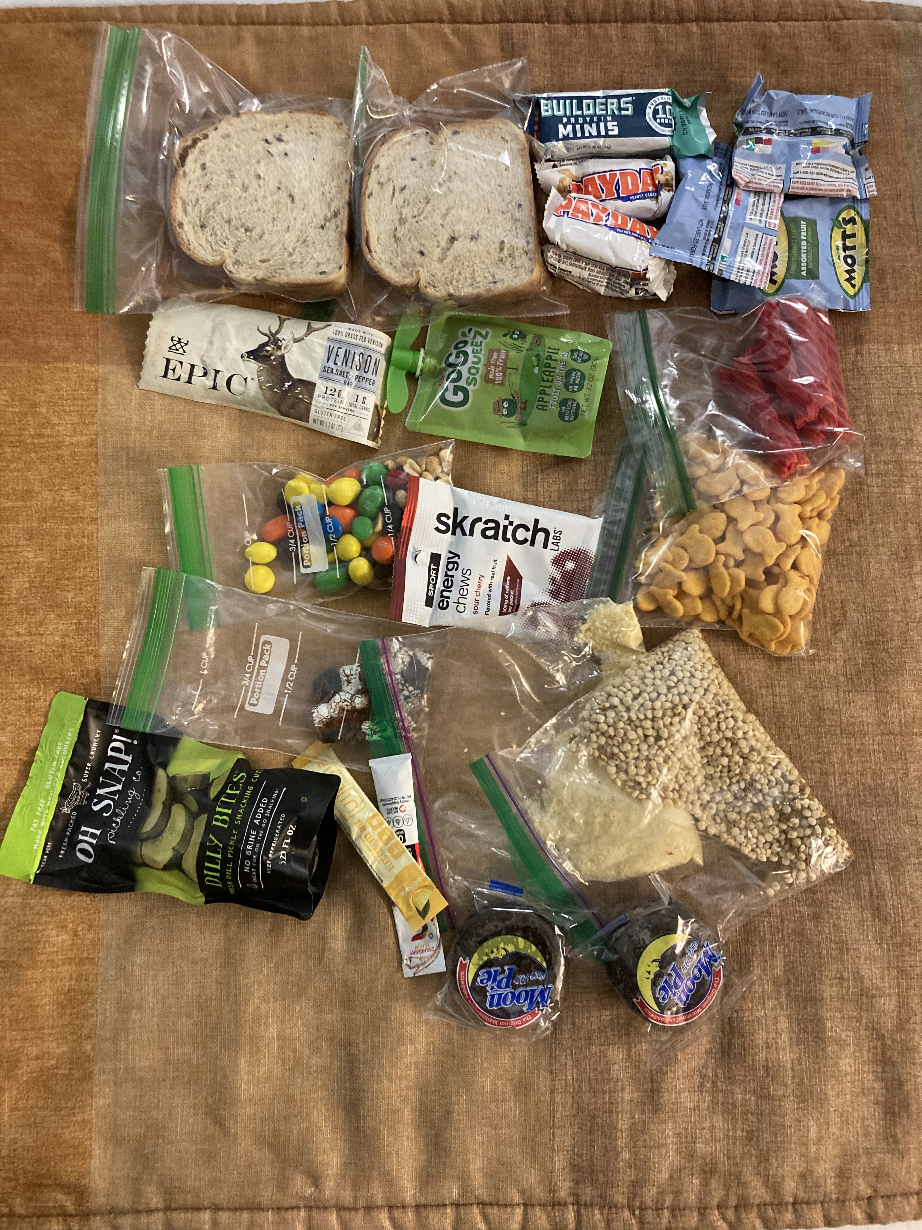
Overall, this was a fun race for me! My goals going in were to get myself lost and then un-lost without following other teams. I wish I had done this a little faster but at least I was able to recover each time and eventually found the CP. I had hoped to place a little higher but the reality of the rental kayaks and my bum shoulder meant that I just couldn’t keep up with teams in canoes or personal kayaks. The nutrition was perfect, the couscous I had made and not used at the Endless Mountains was pretty tasty! I added boiling water to the baggie when I was making coffee in the morning and then just let it sit in my backpack until I was hungry. The same thing works great with ramen! I’m really enjoying the INFINIT nutrition blend while paddling, has helped keep me from bonking when I can’t stop to eat/drink during the paddle. This is a race I hope to make an annual event on my race calendar! Given the large amount of paddling, it would be fun to do this one with Steve and our own canoe and see just how many CP’s we could get!
